RU
RU EN
EN


GPS Tracker |
Feedbacks
 Leave your feedback!
Midlet "GPS Tracker" is intended to perform to track the location (latitude and longitude, and altitude), course and speed of the user's phone, as well as conducting photo report.
System Requirements
| Mobile phone should have a color screen and maintain a profile MIDP 2.0/CLDC 1.0, and API JSR 175 (for positioning), JSR 75 (to save the protocol), JSR 135 (for photos). MIDlet is tested on a mobile phone Nokia 2710 Navigation Edition. |
 |
GPS Tracker is distributed under CC BY-ND 3.0 license ("Attribution-NoDerivs").
Downloads
 |
Midlet is distributed in the form of ZIP-archive containing the files GPSTracker.jad and GPSTracker.jar, designed for installation on the phone with the appropriate software |
Checksum ZIP-archive MD5: ec2231c44782682b30ea120a823c1c35 - 1.0
|
Number of Downloads: 0
GPS Tracker 1.0 (ZIP-archive) - 11,5 КБ (released August 22, 2012) - Download From https://foxylab.com |
Features
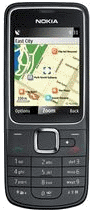
Before running midlet desirable to permit access to the location information, to avoid repeated requests.When you run the midlet splashscreen appears the main form of midlet:
MIDlet poll the GPS-receiver every minute (time-out to get information from satellites - 30 seconds).
After receiving the information from the GPS-receiver, it is displayed on the screen:
Note. Datum WGS (World Geodetic System) 84 - a three-dimensional coordinate system for positioning on the Earth. In the center of the WGS 84 coordinate system coincides with the center of mass of the Earth, and the zero meridian is IERS Reference Meridian, located in the 5.31″ east of the Greenwich meridian. Large equatorial radius of the Earth reference ellipsoid to WGS 84 is 6,378,137 meters, and small polar - 6356 752.314245 m.
Also, the phone displays a compass needle (blue half points to true north, and red - to the south). Compass works only when moving the phone.
If the midlet is allowed access to the file system of the phone, pressing [1] to enable (Logs On) / disable (Logs Off) mode recording the information in the file E:\GPSTracker\GPSTracker.log.
If the midlet is allowed access to the camera and file system phone, pressing the [2] to enable (Shots On) / disable (Shots Off) mode of photo report. The resulting images are saved in the folder E:\GPSTracker into the file named hhmmss.jpg, where hh - hours, mm - minutes, ss - seconds.
If the midlet is allowed access to the file system of the phone, you press [0], you can save a copy of the screen in the folder E:\GPSTracker into the file named Shots_hhmmss.png, where hh - hours, mm - minutes, ss - seconds.
To display help information, click button [OK]:
To close midlet, click button [Exit].
Whats new in GPS Tracker 1.0
* first public versionRead more >
Contacts